Hurricane Gustav Spares New Orleans, More Storms Lurking

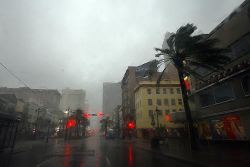
New Orleans, La. - Hurricane Gustav may have spared the city of New Orleans, but other parts of Cajun country have been devastated.
In the low-lying parishes across Louisiana's southeastern and central coast, homes have been destroyed and areas flooded. Governor Bobby Jindal says he's received reports of widespread damage across three parishes (Terrebonne, Lafourche and St. Mary) near where the eye of the storm hit. Helicopter crews are expected to search the area for anyone injured or killed.
The area is home to the state's oil and natural gas industries, and rig owners are heading out to inspect their installations for damage.
We're halfway through the 2008 hurricane season, but the ripe tropics are making it seem far from over.
Hurricane Hanna and Tropical Storm Ike formed Monday, and a new system, Tropical Storm Josephine, popped up Tuesday morning.
**Remember** Be prepared for a Tropical Storm or Hurricane by reading the Hurricane Preparedness Guide provided by HRH/ Kirklin .
A rundown on the three new systems:
- Hanna
- Crawling over the Turks and Caicos Islands and southeastern Bahamas, Hanna was downgraded to a tropical storm Tuesday morning with 70 mph winds. Forecasters expect it to pick up strength and become a hurricane again later Tuesday or Wednesday.
South Florida just barely falls outside of the latest five-day forecast cone, except for a small patch of North Broward County.
Hanna knocked out power to islanders and is expected to drench the drought-affected Turks and Caicos with up to 20 inches of rain. Hanna forced Turks and Caicos officials to cancel the first day of school, and the airports there are closed Tuesday.
As Hanna moves northwest this week and gains strength, the storm will jog up Florida's East Coast, likely bringing some foul weather to South Florida. Landfall is projected near the Carolinas on Friday as a Category 1 or Category 2 hurricane.
"The area of uncertainty is very large at this point and could affect anywhere from South Florida to the Outer Banks of North Carolina," said Jessica Schauer Clark, a National Hurricane Center forecaster. "Everybody should keep an eye on it."
- Ike
- If forecasters' estimates are correct, the Bahamas and the Turks and Caicos islands will be dealing with another hurricane soon after Hanna is out of their hair. Tropical Storm Ike is about halfway between here and Africa, with 50 mph winds, on a path that's due west. Forecasters say it could strengthen into a hurricane by Wednesday and reach the Turks and Caicos by Sunday as a Category 2 storm. It's still unclear where Ike could go after this weekend, but it will likely be close enough to South Florida that it's worth monitoring.
- Josephine
- This quickly organizing storm could grow into a hurricane by Wednesday, but as of Tuesday its maximum winds were 40 mph. Josephine is still far away, just moving toward the Cape Verde Islands off Africa's west coast. Forecasters think strengthening is inevitable as Josephine tracks west over warm water and no competing wind shear. This weekend it is forecast to be somewhere in the middle of the Atlantic between Florida and Africa.
And Gustav became even weaker Tuesday as it moved farther inland toward the Louisiana-Texas border. It is now a tropical depression with 35 mph winds but will continue to dump large amounts of rain in Texas, Oklahoma and Arkansas until it completely breaks up later this week.
Adapted from AP News Wire, weather.com, and the National Hurricane Center. If you would like to see your chapter news here, contact Communications Coordinator Tom McAninch.
The Grand Council of Tau Kappa Epsilon has released our 2020-2025 Strategic Plan. Looking for a way to contribute to the future of TKE? Make a gift to Life Loyal Teke today.